Archive for April 23rd, 2015
April 23, 2015 – Do-Si-Do
What do I say when the superlative scenery vocabulary of the last few days is used up, or overused? I guess I revert to the mundane, or silly!
Today was a quiet travel day away from the fabulous sites of the Canyon lands – and back onto 4-lane travel (for a short time). And if you ask…”Where did you go, and where is Sandy?” The answer might be hummed…
“Somewhere near Salina, Lord.”…”I let her slip away!”
When I shared this stupid tune with Sandy this morning, I got a flinty-eyed look and she said in a dangerous tone…”You’d better not!” We shared a laugh as we both had images of her drifting out the Truck House door as I hard-round another hair-pin, switch-back turn too quickly! So today, instead,…we took a “red road” with slow, wide turns, high speeds, and little elevation changes. Still, this is Utah, so traffic is sparse. I’m not unhappy.
I thought you might be interested in our daily dance routine. Imagine living in a 12 square foot home! As we pass each other moving from one end of our Truck House to the other, hand signals and verbal commands are necessary to keep the Truck House Dance orderly, and free of fisticuffs! “Al-a-man left” works!…as does “Do-si-Do”. We had to drop “Swing your partner”, but in the end, no matter which way we face, we are dancing cheek-to-cheek as we pass.
When one of us says, “I am going upstairs to bed.” that is not a “See you later.” statement. It carries new meaning like – turn out the lights, turn off the furnace, the water heater and electric pump!… and quit moving around!
We are safe and sound with nearly 20 C temps “somewhere near Salina” – at Butch Cassidy Campground. Time to think about a walk down the highway to El Mexicana Restaurant!
Love and best wishes to all!
T and S
p.s. I’m sure that Kris Kristofferson was referring to “Salinas, California”, not Salina, Utah!
April 23, 2015 – Scenery!! – beyond words!
Monday, April 20 – After getting a new tire on Monday morning in Blanning’s only tire store we were ready to tackle the highway 95 up into the Natural Bridges National Monument. It was easy to maintain speeds of 65 mph as the highway, once again, was almost empty. (We have definitely found our share of lonely roads on this trip!) About noonish, we headed off the main highway towards the Visitors’ Centre and campground area (which was full).
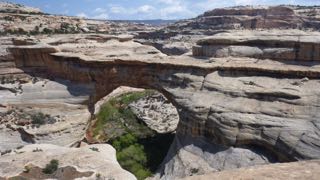
The road then follows a 10 mile loop with stops and trails for each of three natural bridges that are hidden below the mesa rim in the canyons below. The first trail down was a thriller with the well-built trail clinging to the sides of the cliffs. Near the last view point, the trail crawls along a drop-off under an overhang that abruptly ends. Sandy pointed to a bit of a trail leading around the corner of the cliff, and asked a returning hiker, “Where does that trail end?” His reply was, “In sudden death!” He was right…it lead to the edge of the cliff. We clung to the cliff face for our return back up the trail after taking pictures of the Bridge. We continued on around the loop making 3 more stops and shorter hikes to viewpoints and vistas!
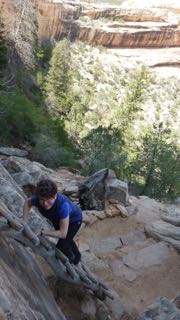
Getting to the overhanging cliff – in the background
A bridge – seen from an overhanging cliff walk

Natural Bridge
Highway 95 then winds around the mesas, and drops into canyons that are part of the Glen Canyon. This is the northern most end of the Colorada River canyon that has been flooded by the Glen Canyon dam at Page, Arizona. As an aside, I have just finished a book entitled “Desert Solitaire” by Edward Abbey. It is a beautiful piece of literature describing Arches National Park as well as part of the Grand Canyon and a trip down Glen Canyon in a rubber inflatable before the dam was completed. The descriptions are beautiful, and do a much better job than my silly title of capturing the incredible beauty of this entire region!
Late on Monday afternoon, we arrived in Hanksville, and found a place at Duke’s Slickrock Cafe and RV Park. This park was comfortable, and neat, if not attractive, though site-numbering left us a bit confused as to where we should set up, and hook-up. No matter! The place didn’t fill up, so we actually occupied 2 sites. After supper we took a walk down the highway and back via “Main Street” in this dusty, deserted, somewhat unattractive town. One teenaged girl was spotted coming down the street declaring loudly into her cell phone…”He always ruins everything!” (Sandy later asked me if I had heard “banjo music” as we strolled through the village!)
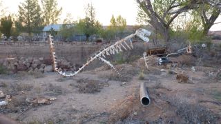
T-Rex – in Hanksville
Tuesday, April 21 – On Tuesday morning we headed off about 9:30 continuing along Hwy 95 towards Torrey, Escalante, and Boulder. Again, stunning views surround us, and in one small roadside canyon stop, we got out to stretch our legs – to the sound of turkey gobbling. Sure enough, we spotted a hen, and then saw the male off in the bushes with full tail feather display.
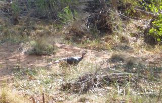
Wild turkey on the run
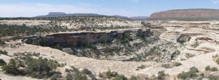
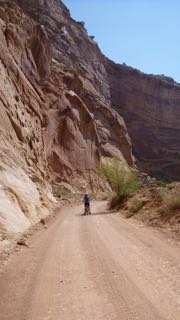
Shortly after, we came to a “Visitors’ Centre” in the historic community of Fruita, UT. We stopped, and decided to explore the Capital Reef National Park in behind the Visitors Centre and we followed a paved road that runs along the Waterfold geological formation. To our surprise, there was a truly beautiful RV Park in the shade under trees on the old Gifford farm – one of several in this historical Mormon community which grew fruit successfully. (We cannot find mention of this in any of our tour guides, or pamphlets!) It was too early in the day for us to take a site, but we carried on up the 10 mile road to the end of the pavement, and then rode our bikes down into the canyon beyond. What a stunning array of overhanging cliffs! Perhaps, this was one of the prettiest side trips we have taken on this journey.
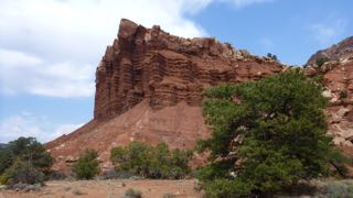
Canyon Reef
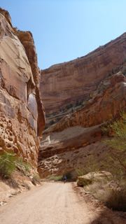
The bike ride down Canyon Reef
On the way out, we stopped in the old farmhouse to purchase a fresh cinnamon bun at the bakeshop, and then continued west through Escalante, and then Boulder, before climbing high (snow still around) over the pass (9600 ft. – with a spit of rain and some fat water near the top) that leads towards Bryce Canyon National Park. This road drops down again into another canyon. As the road climbed again towards Bryce Canyon City, we passed a pull-off to “Mossy Cave”. Naturally, we had to explore this trail. Most notable was a pretty little rushing creek with a waterfall. This creek bed had been dug by hand by Mormons in the last century who wanted to bring water into the valley below!
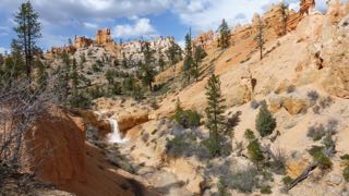
Mormon-carved irrigation from Bryce
We arrived at Bryce Canyon in the late afternoon under a threatening cloud (which later dissipated), and the North Campground was full, but we found lots of room at the Sunset Campground.
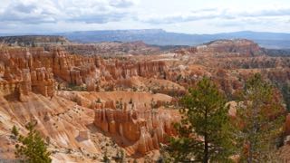
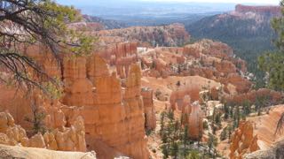
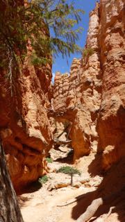
Wednesday, April 22 – Today we decided to take another day here at Bryce Canyon, so we began with a trip to the Visitors’ Centre to get some more cash to pay for our campsite tonight. Then, with sun finally bringing some warmth to the air, we took the 2.2 mi. hike down into the bottom of the canyon and then back up to the top. (Sunset Pt. to Sunrise Pt. to Queens Garden Trail to Navajo Trail.) The exercise felt good, and lunch even better afterwards!
It is now Thursday morning, and tomorrow we will meet up with the Padghams in Green River. Temperatures dropped below 0C last night, but we survived, and all is well.
Best wishes and much love to all!
Tony (the Quill) and Sandy (the Quilter)
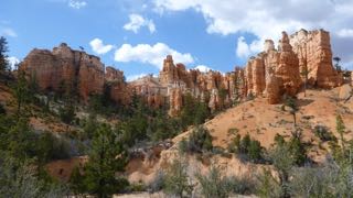
Bryce Canyon
Overview of the trail

Looking up the hiking trail

Looking back down the hiking trail
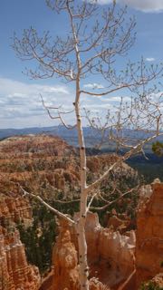
Lonely aspen
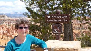
End of 2.2 mi. hike
