Archive for August 12th, 2015
Monday, August 9, 2015 – Six Swans a-Swimming
Since it was early on Monday morning when we de-camped and headed into Haines, nothing was open – except the Tourist Information. The library and its wifi didn’t open until 10:00 a.m. so once again, we are on the road without sending blog notes. They are really beginning to pile up and I wonder if they will be left unread as too time-consuming.
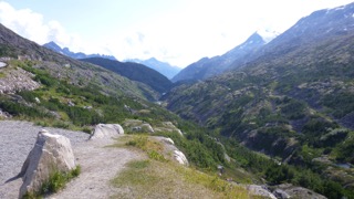
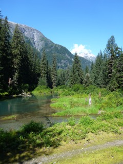
The highway out of Haines follows the Chilkat river estuary for a number of miles until the “Eagle Nest Park” where the road begins a long climb to a summit above the tree line. (Wrong time of year to see eagles, apparently.) Near the top of the climb, we were also very near to the base of the clouds, and suddenly we were in dense fog. This lasted only a short while until we dropped a bit into a fabulous valley that was the “Chilkat Trail” – an alternative to the Chilkoot Pass on the Skagway side. At 3 separate small lakes we saw pairs of beautiful swans – as advertised in brochures.
This highway, once again, is almost deserted, and we had an almost great run all the way to “Discover Yukon RV Park”, an hour or two south of Haines Junction.
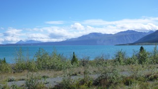
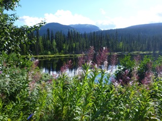
Kluane Lake
We stopped at an information centre just before Kluane Lake. There, we were able to spot a herd of Dall Mountain sheep high on the slopes above us.
The good highway suddenly ended, and frost heaves and potholes began to occur way too frequently. Finally the pavement gave out, and we found ourselves on VERY dusty gravel. I fought my way to the head of the line, and then led the convoy through a series of flag-car stops and starts. Watering trucks put down a spray to reduce the dust, and the resultant was that Truck House ended up being the same colour as the road. Finally, we were somewhat relieved to find “Discover Yukon RV”.
The proprietor of this RV site hails from Manitoba, and comes out each year to run the place. It is a museum for old abandoned equipment – mostly from the US military – equipment that was used in the building of the Alaska Highway in the early days of World War 2. The next day, at the museum in Tok, Alaska (that is pronounced like the pot-smokers’ “toke”.) we read about this project which took 8 months to complete. What a horrendous experience this must have been to young troops out of south-eastern US with no warm clothing, improper equipment, no bug protection, and no experience in muskeg country.
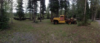
The military machine bone-yard
Tuesday, August 11 – Stoned in Alaska
Okay…I hope that this entry will be a short one since the day was NOT! We left Discover Yukon RV at 9:00 a.m. (PDT) = 8:00 a.m. Alaska Daylight Time, and didn’t arrive at our next campsite (King Mountain State Recreation Park) 69 miles northeast of Anchorage until 5:00 p.m. ADT.
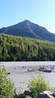
King Mountain
This was by far the longest day of travel that we have encountered so far. Once again, this was a mix of paved road followed by construction stops and following pilot cars. The temperatures floated around 7C all day (getting to 13C as we got nearer to Anchorage) and rain was heavy at times. About two hours before stopping, a rocketing camper truck tossed a very large rock at us which almost burst through the windshield. The windshield will require replacement, but I don’t think that it leaks. My partner was showered with windshield glass! The rain finally ended and by the time we encamped, we were under blue skies and sunshine. We will probably try to keep the windshield until we are back on full paved roads.
Moral – You shouldn’t throw stones!
So today, Wednesday, August 12, we plan to head into Anchorage, get an RV site with wifi and hookups, and explore the city (Pop. of 200,000!)
A couple of hours later… we have found an RV Park – Anchorage’s “Ship Creek”. (“Roada”, our Garmin GPS, makes this sound crude!) We have paid for the site and are happy to announce that this is the second closest that we have ever been to a busy railway…the closest being “Whistle Stop” campground out of Hope, BC. Aren’t we excited! Today, we will explore a bit.
Much love to all and a note: all photos show sunshine. This is not reflective of the daily weather, but only of my desire to take pics!
Tony, The Quill, and Sandy, The Quilter
p.s. We will hit about 3 quilt shops today in Anchorage.
Saturday, August 8, 2015 – Prospecting for Patterns
After debating whether to stay another day at Boya Lake,
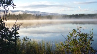
Boya Lake in the early morning
or not, our final decision on Saturday, August 8 was to get to Skagway before shop closing times in case they were not open on Sundays. (A quilt shop is the target.) Highway 37 had some construction and paving happening just north of Boya Lake, but the new, finished road was fabulous driving. The Alaska Highway from the Junction (west of Watson Lake) continued to surprise us with easy driving, and very sparse vehicular traffic. More fuel at Jake’s Corner where the sign on the pump read “Place card in card holder.” After several minutes of searching for the card holder, a young man came to pump our fuel. “Where is the card holder?” I asked. “I am the card holder,” he replied. The turnoff to Atlin was a short distance on, but since I had already visited Atlin a few years ago, and Sandy wasn’t particularly interested, we gave that northern BC town a pass. Our route branched south at Carcross, Yukon.
Looking into Alaska and Skagway
The US Customs at the border heading down into Skagway confiscated a lemon, a red pepper and a tomato, but the young man was very apologetic for having to take these three items. I almost suggested that he take some dressing for his salad, but judiciously bit my tongue.
Besides the stunningly beautiful scenery on the highway to Skagway, the only other thing of note was that after the Customs Building, there is a very long, very steep and very winding road leading down into Skagway. Nearing the Customs House was a young man standing on his bike peddles and grinding his way uphill after several miles of a climb. We were impressed! (Perhaps I will race Sandy up that hill the next time we travel here. Get Serious! I might have trouble getting to the base of the climb!)
A sugary “beaver tail” purchased at Klondike Dough got us a recommendation for a hookup at Gardens City RV. We also located the quilt shop and acquired the required pattern.
We stayed the night beside a tiny homebuilt “teardrop” trailer from Virginia. “Gary and Elaine” gave us the gist of their very long 2 month journey and showed us their very short rig – built for about $3800. Impressive!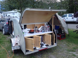
Sunday, August 9, 2015 – Another Chilkoot Pass Failure, and… in Haines Site
We had very spotty wifi last night at Gardens City RV, and it was limited to one hour – not enough time to run my blog notes and pics through the system.
Today (Sunday) we are heading on the ferry to Haines. All stores are open in Skagway, since one or more cruise ships are in daily. (On Wednesday, they expect 10,000 visitors! Today, there were only 2000.)
We made a run out to the Dyea Townsite this morning. I had hoped to catch a glimpse of the “Chilkoot Pass” but the road was potholed and washboarded – and narrow, the area is overgrown, and the only view of the Pass would happen when you do the hiking trail – apparently quite a long trail until you begin the climb. In 1897, this area was a grassy plain, not a tangled forest. Another stroll through Skagway with the Cruisers (Coral Princess), and then we headed for the ferry parking lot to await our crossing to Haines. We boarded the “Malaspina” at 2:30 in preparation for the 3:00 pm sailing.
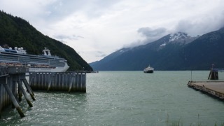
The Malaspina preparing to dock in Skagway
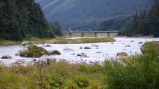
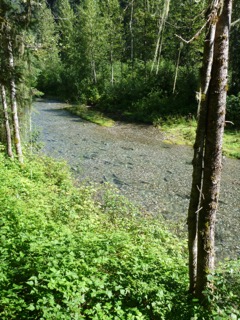
We arrived at Haines at 4:00-ish, and turned right to head away from the town and towards the State Recreation Site of Chilkoot Lake. The Chilkoot River flows into the salt-water estuary, and is quite wide with strong currents, turquoise waters, and many large boulders and fishers! All along the 3 km entrance-way to the camp ground folks were parked and walking, hoping to catch a glimpse of the evening approach of brown bears. At the mouth of the river at Chilkoot Lake fish were jumping and fishers were casting to try their luck. We watched as a few beautiful fish were caught, and then headed in to select our campsite. Later we walked back partway down the road and caught a glimpse of a brown bear sow and her two cubs down near the estuary end of the river. Crowds of folks lined a bridge above the bears to watch as they rambled for food along the bank.
Down below the far left of the bridge are the brown bear and 2 cubs.
Love and best wishes to all…
Tony and Sandy
August 6, 2015 – Prospecting for Gold
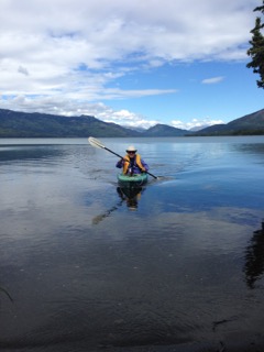
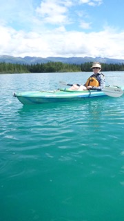
Our run on Thursday, August 6 to Kinaskin Lake was short, and lovely. No rain, but two black bears. Kinaskin Lake was almost deserted at that time of day, so we got a beautiful site and unloaded our kayaks in the sunshine. We were granted a couple of hours of gentle paddling and fly-fishing before winds began to pick up and rain again threatened us. We headed back to camp for books and food.
Our next planned stop on Friday was Dease Lake where I spent a summer underwater in 1969 prospecting (diving) for gold at Dease Creek about 1/2 way up the lake. I was very curious about this place and needed to get some information about the area. (Besides, since BCTV announces the weather conditions daily for Dease Lake, there must be something important about it!) Also, my good buddy, and past (and future) brother-in-law, John Thuot had spent several years mining the gold of Dease Creek in the early 1980’s, and he had given me the name of a contact that I should look up. (By the way, if you are ever visiting the Archives, in Victoria, BC, look up Laketon, BC. It is a fascinating story.)
Brunch at Rumours Cafe got us decent food, but little info, and none of its promised wifi connection, so we fuelled up and continued on the road to “Waters Edge RV”, where I stopped to speak to Chuck Phillips, the proprietor, and John’s partner from his mining operations. Chuck was very informative, and we then continued 16 km to the gravel pit where I showed Sandy where, in early June, 1969, my partner John Chato, and I had hidden his car, and built a raft to cross over the lake with our diving gear and supplies.
I also recalled how, at one point in late July of that summer, when we had to head back to Prince George for more equipment and supplies, we had relaxed in the comfortable seats of the car (after our paddle across the lake) at around 8:00 in the evening and were stunned and excited to listen to the broadcast of Neil Armstrong’s landing on the moon. A while later in the broadcast, after paying amazed attention to the event and the fact that our timing should have been so elegant, the announcer stated…”You have been listening to a re-broadcast of last week’s historical moon landing.” Deep let-down!
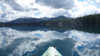
Early in the afternoon on Friday, we arrived at Boya Lake – a spectacularly beautiful lake with varying shades of turquoise. We were able to find a lovely spot with beach access, and got our kayaks quickly into the water for several hours of gorgeous paddling and fly-fishing. Two loons entertained us with repeated calls and a frantic bobbing up and down routine that I had never witnessed. No luck with fishing, but I saw a few distant jumps. A late afternoon shower caught me on the water, but I was headed in anyway, so didn’t quite get soaked. We ate an early dinner at campsite and then headed out again for a clear, absolutely calm, evening paddle and more unsuccessful fishing.
Rest stop on way to Boya Lake
Sandy wondered, since I use golf carts for kayak transporters, if someone would see the empty carts and wonder if we were out on the back 9.
Next note is on the way!
Tony Quill, and Sandy Quilter
August 4, 2015 – Butter’s in the Oven
Well, after a Sunday breakfast with our Thuot family, and another entertaining afternoon and evening with the Siggers clan, we finally got away from Kamloops on Monday morning.
We had received conflicting advice on routes to travel – Hwy 16 to Tete Jaune and then west to Prince George vs Highway 1 to Cache Creek and thence north to Prince George – so we finally decided to leave it to Roada, the Road Garmin. She chose the Cache Creek option. The run to Prince George and Bee Lazee RV Park about 11km south of PG was mostly uneventful, except that in purchasing a new propane tank in 100 Mile House on a fuel stop, I ran over our sewer hose connector which was lying on the pavement. It’s toast! A search through RV Sales, and a Walmart in PG for a replacement was hopeless. We can get along without it, but since we don’t have grey water tank, our sink drain must connect to a 5 gallon drain bucket.
We encountered spotty rain showers and chilly temps from McLeese Lake south of PG through to our late afternoon stop on Tuesday at Kitwanga (Cassiar RV) at the beginning of the Stewart-Cassiar highway 37. Temperature on Tuesday morning at Bee Lazee RV was 7C. Sandy has decided that the way to keep our butter softer is to store it in the oven. It doesn’t work. (I didn’t tell her that the oven wasn’t on.) We hit a quilt shop in Burns Lake for another pattern. I didn’t spot any tool shops.
The Cassiar RV north of the turnoff to Highway 37 at Kitwanga is a very lovely spot. Everything is very green. They have had several weeks of rain, and one couple returning from Alaska told us that they had rain the whole trip. Under threatening skies, Sandy and I walked the trail down to the Kitwanga River to see a “fish count” in operation. The young native at the trap wouldn’t let us take pictures, but he was netting up some really impressive chinooks, pulling scales, and recording sizes. He gave us a very detailed description of everything that he was doing. We were quite impressed. No bears, no rain, however, two adjacent posters on the wall at the office caused me to ponder the dangers!
The Poster
The ambiguous notice
On Wednesday we continued north on beautiful highway 37. There are more pullouts and litter barrels than we have seen anywhere in our travels, and the wilderness is beautiful. On occasion, we encountered wagon trains of big rigs heading south, but kilometres would fly by without seeing another vehicle. (As an aside, in a recent argument about how to pronounce “kilometer”, I supported the view that it is pronounced “KILL’-o-meter” rather than the increasingly common “kil-OM-eter”. An internet search proved that my version was the preferred. “Kilometer” should NOT be pronounced to rhyme with the instruments “thermometer” or “barometer”. A “kilometer” is not an instrument, it is a distance representing 1000 meters. Hence… a kilo meter.) (Are my grammar jackboots showing?)
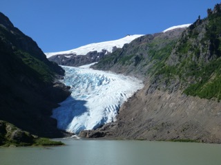
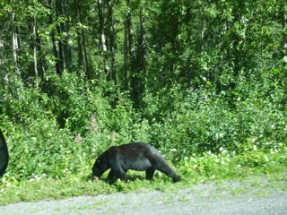
At Meziadin Junction we turned toward Stewart and Hyder, Alaska. We spotted one black bear retreating into the woods, and then we encountered road repair beside a beautiful lake and retreating glacier. This gave us a break and photo op. (There won’t be many more years of glacier photo-ops methinks!) A quick stop at the Stewart Information Centre got us a map of the route to Salmon Glacier on the Hyder side of the border. We continued through the border to a creek observation walkway where bears apparently could be spotted. Not so, however the salmon run was truly impressive with many large battered chinook and a few very hump-backed pinks fighting for spawning gravel. A few miles beyond that, the pavement ended and we began climbing up towards the Salmon Glacier. The road got increasingly rugged, and I switched to 4×4 drive for some of the steeper washboard stuff. After about 10 km we decided that Truck House (and us) had had enough bashing, so we u-turned and retreated. (Two weeks of rain, and no maintenance are both conducive to creating potholes and washboard on a gravel road!) One more glacier that’ll never be seen!
Salmon spawning country
The dark spots in the stream are spawning salmon.
Back at Meziadin Junction, we turned south to the Meziadin Lake Campground and got a lovely spot close to, but not on the lake. This is a well-maintained, and very full campground. This has a few full hook-up sites, so it attracts the big-rigs!
Since I have not not written much in the past week, I suddenly realized that this blog would be about 4 pages long. In consequence, I will break this monologue up into separate entries in order for readers to take bathroom breaks, or whatever. Stay tuned!
Love and best wishes!
Tony, The Quill, and Sandy, The Quilter
