Archive for the ‘Uncategorized’ Category
May 1, 2015 – Speeding past Salt Lake Sand Flats, and other tales
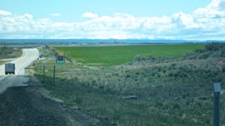
Thursday, April 30 – What did I tell you? The horses are heading for the barn! Speed works! So there we were, high-tailing it away from the traffic jams around Salt Lake City on Thursday morning when we were delighted to see the new speed limit of…80 MPH! Now that is rocketing! Funny thing – we saw more traffic cops than we have encountered on this trip, and even better – they actually had folks stopped who were exceeding the speed limit of 80 mph (135 kmph)! – and the speedsters weren’t “Craig Breedlove”! And speaking of whom, we did stop by the beautiful white Bonneville Salt Flats of Salt Lake to see where land speed records have been set. (Latest record was set on October 23,1970 by Greg Gabelich who beat Craig Breedlove’s record of 600.601 mph with 622.407 mph – according to the sign.)
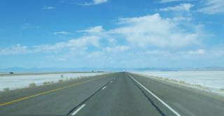
Salt Lake Flats speedway – Limit = 80 mph!
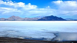
Bonneville Salt Flats off in the distance
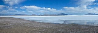
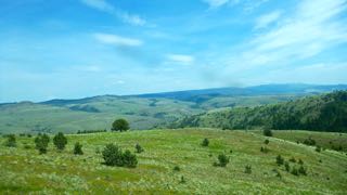
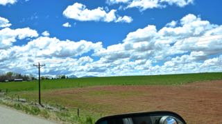
Panorama view of Salt Lake Flats
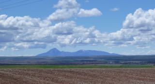
We headed on west on Hwy 80 (speed limit dropped to 70 at the Nevada border) until Winnemucca where we found a spot for the evening at the KOA. Scenery continued to amaze us!
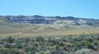
Nevada hill shows shades of grey
Friday, May 1 – This morning, we headed north on 95 (which became 78, then 395) all the way to Pendleton, OR. As we left Winnemucca this morning, Sandy asked if I should refuel. I scoffed at the suggestion as I was looking at over 1/2 tank of fuel. Three hours later, we hadn’t seen a gas station, and I was beginning to wonder how many miles I would have left after the tank started flashing its empty light. Meanwhile, many, many small rodents were dashing across the road as we roared by, and by the red, furry, spotted look of the tarmac, many more had been a whole lot less successful at making it to the other side. I called them “gophers”, but these seemed to be a bit smaller than those prairie dogs.
Our Garmin showed that there was a fueling station at a place called “Crane”, so I willed Truck House on by holding my breath. Just before we arrived at Crane, we saw a fellow sitting in a lawn chair out in a field. We laughed at this, but then discovered that he was holding a rifle with a scope. (Not so funny!) As we carried on, many more guys were out with rifles and scopes and obviously were out to shoot game of some sort. (Hopefully not in each others’ directions!)
Crane, Oregon has a single fuel pump and diesel cost $3.209. That is the most expensive that we have encountered on our trip. (Most diesel prices ranged from about $2.69 per gallon to $2.99 per gallon. That’s $.71 to $.79 per litre!!) I asked the lady who ran the pump about the “guys with guns”. They are shooting “sage rats” she declared. I must have look puzzled for she went on… “Some people call them gophers; others say ‘ground squirrels’, but they are big pests, and eat a lot of alfalfa.” (Sandy Googled “Sage Rats” a few minutes ago. It is all true! The “Big Game” was a sage rat!! Look it up!)
The rest of the trip to Pendleton was up and down with at least 5 passes to be crossed. (Maximum altitude of about 5500 ft.)
Beautiful rolling hills of SE Oregon
We will probably make it across Washington tomorrow, but aren’t completely certain. If we stop to shop anywhere, we might have one more night before making it to the lower mainland.
Love and best wishes to all!
Tony (the Quill) and Sandy (the Quilter)
p.s. I offered to stop in 2 separate quilting shops today, but Sandy “passed”. I still get the points!
April 29, 2015 – A change of plans, and a re-roading
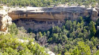
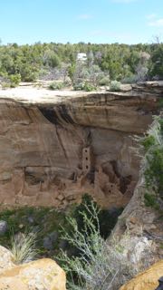
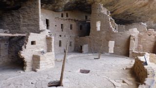
Our plan on Tuesday was to visit Mesa Verde, so we headed up to the Visitors Center at 9:00. From the VC into the scenic mesas (one still closed for winter) is a long climb of about 20 miles. The temperatures hovered around 10 C to 12 C, so we stayed in sweats and down vests as we toured all the walk-in sites along the top of one of the mesa loops in the bright sun. Some of the Ancestral Pueblan sites are surface pueblo structures on the mesa tops, while the later (900 AD to 1200 AD) were cliff dwellings – some with three story apartments. (BTW…the term “Anasazi” is no longer used as apparently it was a Navajo word, not a Pueblan word, and it referred either to the “Ancient ones” or “Ancient enemies”.) There seems to be no mystery as to why they were abandoned somewhere around 1300 AD. There was a prolonged drought of about 25 years, and the clans moved south. Their ancestors remain to this day in tribes such as the Zuni.
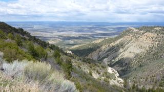
Looking north to Cortez, CO
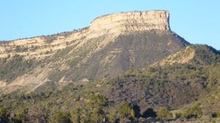
The Mesa Verde north entrance
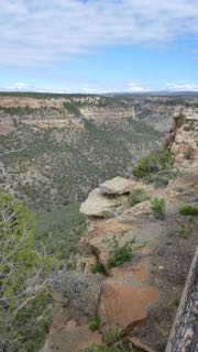
Mesa tops and canyon
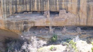
Cliff dwellings upon cliff dwelling (Keeping up ABOVE the Joneses!)
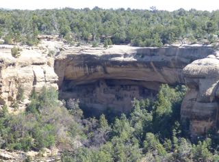
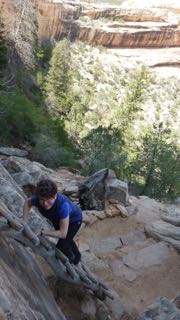
From the Museum at the end of the loops, there is a walk down to the Spruce House which is open to the public, so the four of us hiked down to tour this cliff dwelling. After the tour, Sandy and I stayed for the 1/2 hour video, while Bob and Alice continued on to do their circuit of the loop that we had visited earlier.
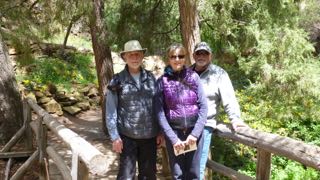
Tony, Alice and Bob (Sandy is climbing the cliff as we watch!)
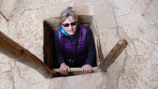
Alice goes into a Kiva in Spruce House

Spruce House
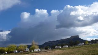
The weather stayed beautiful until late in the afternoon, when the continuing pattern of disturbed weather descended on us and threatening clouds moved in from the west. The four of us shared supper in the Padgham’s trailer, and then ended the evening early.
This morning, we received word that Sandy’s uncle had passed away in the night, and though it wasn’t unexpected, we decided that a continuing sense of joy of discovery was going to be more difficult, and so we decided to make the turn for home a few days early. We called Santa Fe to cancel our reservation at the RV park there, and turned back towards Monticello, Moab, and Green River. (The Padghams were heading back to Moab, then Zion and Bryce to spend a few more days in Utah.)
The re-roading was okay (I try not to travel on the same routes if I can help it) as it gave us a different perspective, and different light of day on the beautiful sceneries! At Green River, we turned north up 191 towards Salt Lake City and headed for our chosen site tonight at Draper, UT.

Looking towards Monticello, UT
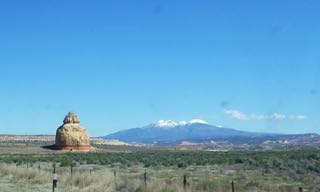
New snow on the La Sal Mountains
Truck House waits below road side arch
Tomorrow, we will head west of Salt Lake City to see the Great Salt Lake flats. The horses are heading for the barn, and you will all be familiar with the single-minded speed that that process takes.
Much love, best wishes and hugs to all!
Tony (the Quill) and Sandy (the Quilter)
April 26, 2015 – Bringing coast weather to the desert
On Friday, April 24, we had a short haul of about 100 miles to Green River from Salina. We quickly located our pre-booked site at Green River State Park RV, and awaited the arrival of our fellow travellers from Whitefish, Montana – Bob and Alice Padgham. As we began to settle in to our site the State Park Ranger came by in his golf cart. The sun was quite warm, but we moved out of the shade to have a brief chat with him. An inadvertent and innocent question elicited a lengthy and far-ranging answer that kept us captive for the best part of the next half-hour. As we stood in the sun, from the shade canopy of his golf cart, he provided opinions on a wide array of historical, political and social events. Well, he was very friendly!
The Padghams arrived an hour or two after us, and we planned our next few days together. Our original plans of meeting with our friends (including another couple) in Santa Fe, have had to be abandoned. First of all, we learned that the Haafs, still back home, had had to cancel their travel plans because of an eye injury sustained in a pickle-ball game. Now, we discover, that the Padghams’ time table has had to be shortened because of travel document meetings that have been scheduled much earlier than they had expected. So, we will have two more days with them when they will turn west towards Zion and Bryce before heading home, while we continue heading east to Santa Fe on our own.
Meanwhile, although the RV Park didn’t have its full complement of RVs, we suddenly realized that there was a city of small tents being set up right next to us, and within the hour, a number of college-aged young ladies were busily running around with clipboards and organizing large numbers of back-packs around each tent. As one young lady came by our site, I asked her what was happening. Apparently there were 21 counsellors from a college running a special outdoor program and they were just waiting for their clients to show up – 70 grade 7 girls! Sure enough by 4:00 there were hordes of young teens gathered into groups with counsellors, and being organized into tents and given sets of rules. Tomorrow morning, they are off “for 5 days hiking in the canyons”. They were all well behaved, and we got a kick out of 70 girls all with braided hair, trying to get ready for a 5 day outdoor adventure. During the night, it rained quite heavily, but by morning, we woke to sunshine and blue skies.
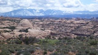
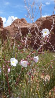
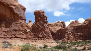
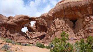
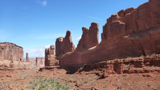
We watched as the young girls were being given final instructions for packing (no make-up bags), but we were on our way in two vehicles headed to Arches National Monument before they were ready to leave. We arrived at Arches about 3/4 of an hour later to see a long line of cars waiting to enter the park. We were finally into the Park within about another 1/2 hour, then we began the switch-back climb up towards more geological wonders! This was a 2-battery day for my camera, and once again stunning vistas and amazing rock formations had us pulling off into all the lookout areas.
Sandy and I are just about rocked out! Rolling hills, and green farm fields would provide a nice respite from the eye-candy of cliffs, mesas, canyons, hoodoos, and arches! As we made our way through the Park, ominous dark thunderheads piled up to the west of us, and since there was a weather warning for Arches, and Moab, we hurried to complete the tour. On the road to Delicate Arch, we crossed over an arroyo that had water in it from a storm from the previous day or two. I mentioned that I would rather be on the “safe” side of it before this new menace broke.
The La Sal mountains – with fresh snow.
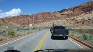
Lineup for Arches!
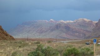
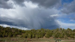
Storm clouds gather over Arches
Sure enough, by the time we reached the Visitors Centre at the end of our Arches visit, we watched some lighting, and rain drops were starting to splatter our windshield. Back at Green River, it was raining steadily. We joined the Padghams in their trailer for appies, while the rain bucketed down outside, and later, during the night we listened to it drumming on our roof for most of the night.
This morning, Sunday, I checked the weather forecast for Moab, and learned that the road to Delicate Arch in the Park had been closed last night, and I had visions of the drenching that the young outdoor adventurers must have had last night. They will have a tale to tell their school chums! It was very chilly here, but Sandy and I rode our bikes to Silver Eagle Gas and Coffee Shop to get Wifi. By the time we returned, the Padghams had exercised their Springer Spaniel, Ike, and the four of us headed out on a 10 mile ride to the Green River Airport – a building out in the desert at the end of a deserted paved road.

Sandy, Bob, Alice and Tony at turn-around to 10 mile ride
The sky cleared, and back at the campground, we were able to sit and read outside in our lawn chairs. The forecast for the next week shows increasing sun and warm temperatures. This is what we came for!
Monday, April 27…On our way just shortly after 9:00 with Mesa Verde as our destination today. Since the Park Campgrounds are not open for another couple of days, we opted to book Mesa Verde RV Campground just outside the Park. Once again we headed on the road towards Arches and Moab, and as we travelled we listened to NPR (our only radio choice when in the US), and a broadcast talking about top books to read. One of the program guests owned a bookstore in Moab – “Back of Beyond”, and one of his strong recommendations was a book about Edward Abbey – the author of the book I just finished – “Desert Solitaire”. Since I have very mixed feelings about the author, I decided to try to find the store in Moab. I parked on Main Street, and Sandy got out and disappeared into a bookstore right beside Truck House. I looked up and sure enough – it was “Back of Beyond”! I went in, pointed to the man behind the counter, and told him, “I just heard you on NPR a few minutes ago!” He was thrilled, and I ended up buying the book that he recommended on Edward Abbey. He wins!
At Monticello (pronounced here as “mon-ta-cell’-o”) we turned east towards Colorado and within a mile or two, there were the landscape scenes that I dreamed of yesterday when I mentioned the “rocked out” comment.
For a while today, the temperatures got up near 20 C in Moab, but now, we are once again in chilly air with threatening black clouds. Perhaps they will by-pass us! Tomorrow, we will explore the Mesa Verde area as we “rock on”!
Much love and best wishes to all of you! We begin to feel the pull of the quilting cutting table and whirring sergers, workbenches and whining table saws!
Q and Q
April 23, 2015 – Do-Si-Do
What do I say when the superlative scenery vocabulary of the last few days is used up, or overused? I guess I revert to the mundane, or silly!
Today was a quiet travel day away from the fabulous sites of the Canyon lands – and back onto 4-lane travel (for a short time). And if you ask…”Where did you go, and where is Sandy?” The answer might be hummed…
“Somewhere near Salina, Lord.”…”I let her slip away!”
When I shared this stupid tune with Sandy this morning, I got a flinty-eyed look and she said in a dangerous tone…”You’d better not!” We shared a laugh as we both had images of her drifting out the Truck House door as I hard-round another hair-pin, switch-back turn too quickly! So today, instead,…we took a “red road” with slow, wide turns, high speeds, and little elevation changes. Still, this is Utah, so traffic is sparse. I’m not unhappy.
I thought you might be interested in our daily dance routine. Imagine living in a 12 square foot home! As we pass each other moving from one end of our Truck House to the other, hand signals and verbal commands are necessary to keep the Truck House Dance orderly, and free of fisticuffs! “Al-a-man left” works!…as does “Do-si-Do”. We had to drop “Swing your partner”, but in the end, no matter which way we face, we are dancing cheek-to-cheek as we pass.
When one of us says, “I am going upstairs to bed.” that is not a “See you later.” statement. It carries new meaning like – turn out the lights, turn off the furnace, the water heater and electric pump!… and quit moving around!
We are safe and sound with nearly 20 C temps “somewhere near Salina” – at Butch Cassidy Campground. Time to think about a walk down the highway to El Mexicana Restaurant!
Love and best wishes to all!
T and S
p.s. I’m sure that Kris Kristofferson was referring to “Salinas, California”, not Salina, Utah!
April 23, 2015 – Scenery!! – beyond words!
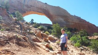
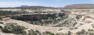
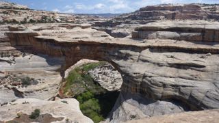
Monday, April 20 – After getting a new tire on Monday morning in Blanning’s only tire store we were ready to tackle the highway 95 up into the Natural Bridges National Monument. It was easy to maintain speeds of 65 mph as the highway, once again, was almost empty. (We have definitely found our share of lonely roads on this trip!) About noonish, we headed off the main highway towards the Visitors’ Centre and campground area (which was full).
The road then follows a 10 mile loop with stops and trails for each of three natural bridges that are hidden below the mesa rim in the canyons below. The first trail down was a thriller with the well-built trail clinging to the sides of the cliffs. Near the last view point, the trail crawls along a drop-off under an overhang that abruptly ends. Sandy pointed to a bit of a trail leading around the corner of the cliff, and asked a returning hiker, “Where does that trail end?” His reply was, “In sudden death!” He was right…it lead to the edge of the cliff. We clung to the cliff face for our return back up the trail after taking pictures of the Bridge. We continued on around the loop making 3 more stops and shorter hikes to viewpoints and vistas!
Getting to the overhanging cliff – in the background
A bridge – seen from an overhanging cliff walk

Natural Bridge
Highway 95 then winds around the mesas, and drops into canyons that are part of the Glen Canyon. This is the northern most end of the Colorada River canyon that has been flooded by the Glen Canyon dam at Page, Arizona. As an aside, I have just finished a book entitled “Desert Solitaire” by Edward Abbey. It is a beautiful piece of literature describing Arches National Park as well as part of the Grand Canyon and a trip down Glen Canyon in a rubber inflatable before the dam was completed. The descriptions are beautiful, and do a much better job than my silly title of capturing the incredible beauty of this entire region!
Late on Monday afternoon, we arrived in Hanksville, and found a place at Duke’s Slickrock Cafe and RV Park. This park was comfortable, and neat, if not attractive, though site-numbering left us a bit confused as to where we should set up, and hook-up. No matter! The place didn’t fill up, so we actually occupied 2 sites. After supper we took a walk down the highway and back via “Main Street” in this dusty, deserted, somewhat unattractive town. One teenaged girl was spotted coming down the street declaring loudly into her cell phone…”He always ruins everything!” (Sandy later asked me if I had heard “banjo music” as we strolled through the village!)
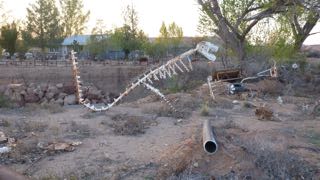
T-Rex – in Hanksville
Tuesday, April 21 – On Tuesday morning we headed off about 9:30 continuing along Hwy 95 towards Torrey, Escalante, and Boulder. Again, stunning views surround us, and in one small roadside canyon stop, we got out to stretch our legs – to the sound of turkey gobbling. Sure enough, we spotted a hen, and then saw the male off in the bushes with full tail feather display.
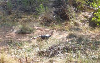
Wild turkey on the run
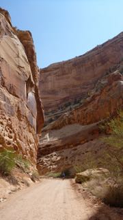
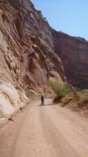
Shortly after, we came to a “Visitors’ Centre” in the historic community of Fruita, UT. We stopped, and decided to explore the Capital Reef National Park in behind the Visitors Centre and we followed a paved road that runs along the Waterfold geological formation. To our surprise, there was a truly beautiful RV Park in the shade under trees on the old Gifford farm – one of several in this historical Mormon community which grew fruit successfully. (We cannot find mention of this in any of our tour guides, or pamphlets!) It was too early in the day for us to take a site, but we carried on up the 10 mile road to the end of the pavement, and then rode our bikes down into the canyon beyond. What a stunning array of overhanging cliffs! Perhaps, this was one of the prettiest side trips we have taken on this journey.
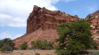
Canyon Reef
The bike ride down Canyon Reef
On the way out, we stopped in the old farmhouse to purchase a fresh cinnamon bun at the bakeshop, and then continued west through Escalante, and then Boulder, before climbing high (snow still around) over the pass (9600 ft. – with a spit of rain and some fat water near the top) that leads towards Bryce Canyon National Park. This road drops down again into another canyon. As the road climbed again towards Bryce Canyon City, we passed a pull-off to “Mossy Cave”. Naturally, we had to explore this trail. Most notable was a pretty little rushing creek with a waterfall. This creek bed had been dug by hand by Mormons in the last century who wanted to bring water into the valley below!
Mormon-carved irrigation from Bryce
We arrived at Bryce Canyon in the late afternoon under a threatening cloud (which later dissipated), and the North Campground was full, but we found lots of room at the Sunset Campground.
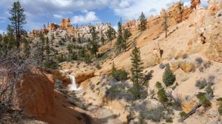
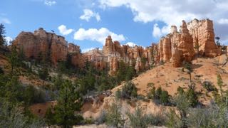
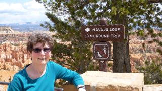
Wednesday, April 22 – Today we decided to take another day here at Bryce Canyon, so we began with a trip to the Visitors’ Centre to get some more cash to pay for our campsite tonight. Then, with sun finally bringing some warmth to the air, we took the 2.2 mi. hike down into the bottom of the canyon and then back up to the top. (Sunset Pt. to Sunrise Pt. to Queens Garden Trail to Navajo Trail.) The exercise felt good, and lunch even better afterwards!
It is now Thursday morning, and tomorrow we will meet up with the Padghams in Green River. Temperatures dropped below 0C last night, but we survived, and all is well.
Best wishes and much love to all!
Tony (the Quill) and Sandy (the Quilter)
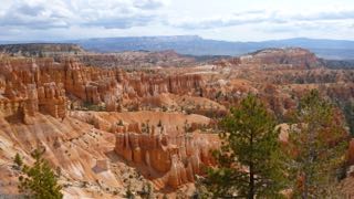
Bryce Canyon
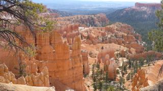
Overview of the trail

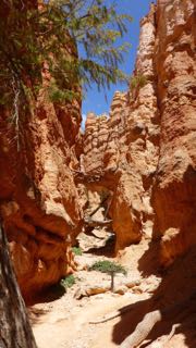
Looking up the hiking trail

Looking back down the hiking trail
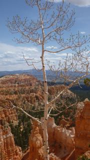
Lonely aspen
End of 2.2 mi. hike
