April 23, 2015 – Do-Si-Do
What do I say when the superlative scenery vocabulary of the last few days is used up, or overused? I guess I revert to the mundane, or silly!
Today was a quiet travel day away from the fabulous sites of the Canyon lands – and back onto 4-lane travel (for a short time). And if you ask…”Where did you go, and where is Sandy?” The answer might be hummed…
“Somewhere near Salina, Lord.”…”I let her slip away!”
When I shared this stupid tune with Sandy this morning, I got a flinty-eyed look and she said in a dangerous tone…”You’d better not!” We shared a laugh as we both had images of her drifting out the Truck House door as I hard-round another hair-pin, switch-back turn too quickly! So today, instead,…we took a “red road” with slow, wide turns, high speeds, and little elevation changes. Still, this is Utah, so traffic is sparse. I’m not unhappy.
I thought you might be interested in our daily dance routine. Imagine living in a 12 square foot home! As we pass each other moving from one end of our Truck House to the other, hand signals and verbal commands are necessary to keep the Truck House Dance orderly, and free of fisticuffs! “Al-a-man left” works!…as does “Do-si-Do”. We had to drop “Swing your partner”, but in the end, no matter which way we face, we are dancing cheek-to-cheek as we pass.
When one of us says, “I am going upstairs to bed.” that is not a “See you later.” statement. It carries new meaning like – turn out the lights, turn off the furnace, the water heater and electric pump!… and quit moving around!
We are safe and sound with nearly 20 C temps “somewhere near Salina” – at Butch Cassidy Campground. Time to think about a walk down the highway to El Mexicana Restaurant!
Love and best wishes to all!
T and S
p.s. I’m sure that Kris Kristofferson was referring to “Salinas, California”, not Salina, Utah!
April 23, 2015 – Scenery!! – beyond words!
Monday, April 20 – After getting a new tire on Monday morning in Blanning’s only tire store we were ready to tackle the highway 95 up into the Natural Bridges National Monument. It was easy to maintain speeds of 65 mph as the highway, once again, was almost empty. (We have definitely found our share of lonely roads on this trip!) About noonish, we headed off the main highway towards the Visitors’ Centre and campground area (which was full).
The road then follows a 10 mile loop with stops and trails for each of three natural bridges that are hidden below the mesa rim in the canyons below. The first trail down was a thriller with the well-built trail clinging to the sides of the cliffs. Near the last view point, the trail crawls along a drop-off under an overhang that abruptly ends. Sandy pointed to a bit of a trail leading around the corner of the cliff, and asked a returning hiker, “Where does that trail end?” His reply was, “In sudden death!” He was right…it lead to the edge of the cliff. We clung to the cliff face for our return back up the trail after taking pictures of the Bridge. We continued on around the loop making 3 more stops and shorter hikes to viewpoints and vistas!
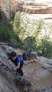
Getting to the overhanging cliff – in the background
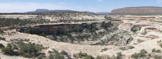
A bridge – seen from an overhanging cliff walk

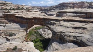
Natural Bridge
Highway 95 then winds around the mesas, and drops into canyons that are part of the Glen Canyon. This is the northern most end of the Colorada River canyon that has been flooded by the Glen Canyon dam at Page, Arizona. As an aside, I have just finished a book entitled “Desert Solitaire” by Edward Abbey. It is a beautiful piece of literature describing Arches National Park as well as part of the Grand Canyon and a trip down Glen Canyon in a rubber inflatable before the dam was completed. The descriptions are beautiful, and do a much better job than my silly title of capturing the incredible beauty of this entire region!
Late on Monday afternoon, we arrived in Hanksville, and found a place at Duke’s Slickrock Cafe and RV Park. This park was comfortable, and neat, if not attractive, though site-numbering left us a bit confused as to where we should set up, and hook-up. No matter! The place didn’t fill up, so we actually occupied 2 sites. After supper we took a walk down the highway and back via “Main Street” in this dusty, deserted, somewhat unattractive town. One teenaged girl was spotted coming down the street declaring loudly into her cell phone…”He always ruins everything!” (Sandy later asked me if I had heard “banjo music” as we strolled through the village!)
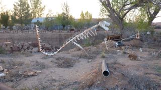
T-Rex – in Hanksville
Tuesday, April 21 – On Tuesday morning we headed off about 9:30 continuing along Hwy 95 towards Torrey, Escalante, and Boulder. Again, stunning views surround us, and in one small roadside canyon stop, we got out to stretch our legs – to the sound of turkey gobbling. Sure enough, we spotted a hen, and then saw the male off in the bushes with full tail feather display.
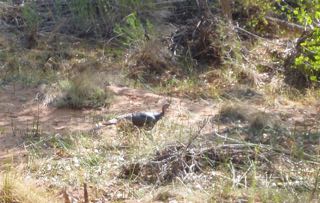
Wild turkey on the run
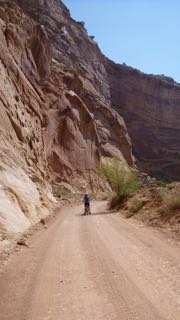
Shortly after, we came to a “Visitors’ Centre” in the historic community of Fruita, UT. We stopped, and decided to explore the Capital Reef National Park in behind the Visitors Centre and we followed a paved road that runs along the Waterfold geological formation. To our surprise, there was a truly beautiful RV Park in the shade under trees on the old Gifford farm – one of several in this historical Mormon community which grew fruit successfully. (We cannot find mention of this in any of our tour guides, or pamphlets!) It was too early in the day for us to take a site, but we carried on up the 10 mile road to the end of the pavement, and then rode our bikes down into the canyon beyond. What a stunning array of overhanging cliffs! Perhaps, this was one of the prettiest side trips we have taken on this journey.
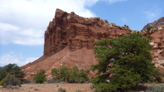
Canyon Reef
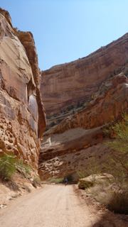
The bike ride down Canyon Reef
On the way out, we stopped in the old farmhouse to purchase a fresh cinnamon bun at the bakeshop, and then continued west through Escalante, and then Boulder, before climbing high (snow still around) over the pass (9600 ft. – with a spit of rain and some fat water near the top) that leads towards Bryce Canyon National Park. This road drops down again into another canyon. As the road climbed again towards Bryce Canyon City, we passed a pull-off to “Mossy Cave”. Naturally, we had to explore this trail. Most notable was a pretty little rushing creek with a waterfall. This creek bed had been dug by hand by Mormons in the last century who wanted to bring water into the valley below!
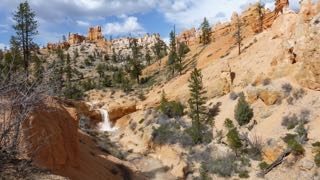
Mormon-carved irrigation from Bryce
We arrived at Bryce Canyon in the late afternoon under a threatening cloud (which later dissipated), and the North Campground was full, but we found lots of room at the Sunset Campground.
Wednesday, April 22 – Today we decided to take another day here at Bryce Canyon, so we began with a trip to the Visitors’ Centre to get some more cash to pay for our campsite tonight. Then, with sun finally bringing some warmth to the air, we took the 2.2 mi. hike down into the bottom of the canyon and then back up to the top. (Sunset Pt. to Sunrise Pt. to Queens Garden Trail to Navajo Trail.) The exercise felt good, and lunch even better afterwards!
It is now Thursday morning, and tomorrow we will meet up with the Padghams in Green River. Temperatures dropped below 0C last night, but we survived, and all is well.
Best wishes and much love to all!
Tony (the Quill) and Sandy (the Quilter)
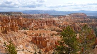
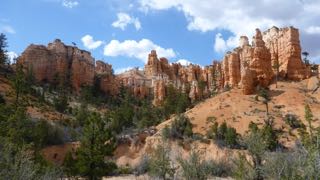
Bryce Canyon
Overview of the trail

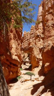
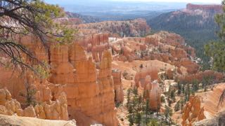
Looking up the hiking trail

Looking back down the hiking trail
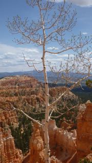
Lonely aspen
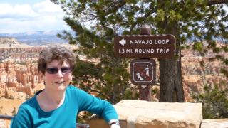
End of 2.2 mi. hike
April 19, 2015 – Flat Tops and a Flatter Tire
We’ve come a few miles since Zion! On Friday, we left Zion after the early birds began to gather as early as 7:30 a.m. These are the campers who are on the prowl for the best spots that become vacant early in the day. If you make any moves around your site, they stop and ask if they can have your site. This is normal and the accepted practice. It is essentially what we were doing four days before that, however we were only looking at vacant sites…we were not aware that you could aggressively campaign for sites that would be vacant within an hour or two. Now we know the drill! Our site, being prime, was snapped up before 8:00, and water jugs left in front to “boogeyize it”!
Our road climbed and switched back up to the east until we were stopped at the mile-long tunnel. (Our $15 fee for blocking traffic was already paid.) The canyon cliffs and rock formations are truly spectacular, and they became even more unreal as we climbed even further east. The swirls and patterns of the sandstone are stunning, and worthy of many photos. (No wonder Kodak went belly-up with the advent of digital!)
At Kanab, we swung south on 89A (Alternate) since we haven’t travelled on that road before, and it was marked as scenic on the map…and it was…in a bleak sort of way. It had none of the spectacular beauty that we had been seeing to the northwest, however it was notable in that there was a skiff of snow on the ground at Jacob Lake. (The road south to the North Rim of the Grand Canyon from Jacob Lake was still closed due to winter conditions.) We finally dropped down and down from the high country into the sandstone cliffs that fence in the Colorado River. These are also very photogenic, but there aren’t a lot of places to pull over and take photos. We drove on by Lee’s Ferry, but someday, perhaps I shall make a stop there. John D. Lee is a prominent character in Utah history and was the captain of the Mormon Militia at the Mountain Meadow Massacre. He hid out for a time and operated Lee’s Ferry across the Colorado River, but he eventually returned to Utah and was captured by US military, tried and elected death by firing squad.
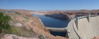
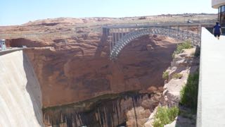
At Page, AZ, we found Page-Lake Powell Campground and stayed for 2 nights. On Saturday morning, we explored the Glen Canyon dam site (amazing engineering that created Lake Powell).
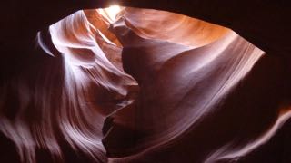
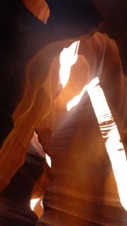
Then we headed up Hwy 98 to Antelope Canyon where we paid entry to the Navajo Park, and then bought tickets for the tour of Upper Antelope Canyon – along with many other folks! A fleet of pick-up trucks seating 10 in the back under a “ramada” frame carry the visitors up to a fissure in the canyon wall that goes for over a mile – open at the top so light comes in to provide incredible scenes of rock formations and sandstone carved by wind and water. Once again, photo opportunities are everywhere, and the guide, who seemed to know everything about everyones’ cameras, helpfully assisted with picture-taking throughout the winding fissure climb.
Today after fuelling, we headed back to Hwy 98 and carried on to 160 and then to 163. This route took us through Monument Valley – more breathtaking scenery – this time of distant flat-topped mesas and sometimes rolling sandstone hills through the Navajo Nation. We turned towards the entrance to Monument Valley Navajo Tribal Park, but decided that we would, instead, stop and take roadside pics. I pulled over, Sandy took a photo, and when I started to pull ahead on the shoulder, our right rear tire blew out with a BANG! I slowly pulled ahead to where a road access entry provided a bit more level ground, and, partially blocking the access, we began the process of changing a flat tire – something I have never done on the GMC! BTW…I had driven over a stub of a sign pipe that had been broken off above ground level. The tire is ruined!
Out comes the manual! I managed to get the jack components out from their storage in the extended cab, but the small jack was going to be a problem with the camper listing to starboard. So…off come the bikes and as I was beginning to take off the bicycle rack two vehicles had to pull around me to get down the access road. The young man (and wife) in the second vehicle offered to help, so after checking out the situation, he made a quick run home to get some more tools. (My new rims won’t accept the standard wheel wrench!) He returned shortly and within 1/2 hour had the truck up, the wheel off and the spare on. We were so grateful to Xavier for his (and his wife’s) assistance.
Although the spare is a bit low on air, we made it to Bluff, UT, and are now at Cottonwood RV Park where we used our Canadian Tire electric pump to add a bit more air to the spare tire. The town is most likely named for the sheer sandstone cliffs that surround us in this valley. Tomorrow (Monday) we will try to get a replacement tire in Blanding, and then begin our next adventure through Central Utah – Plateau Country to Bryce Canyon before heading east again through Arches National Park, and Moab. Snow showed prominently on the mountains to the northwest today. I hope that the weather warms before we hit the high country again in a couple of days.
April 16, 2015 – Sunshine, and useless sunscreen.
We didn’t get back to the small cafe for coffee and wifi yesterday. So, here we are today! And BTW…I have no idea where the name “Desert Pete’s” comes from! Perhaps it was just a further example of inventive truth-telling in my blog, or creative licence! (The coffee shop is called Deep Creek Coffee!) Instead, we biked up to the “Junction” (where the access road heading north into the canyon forks with the main thoroughfare heading east towards Mt. Carmel, and the rest of Utah.) This was a very chilly ride and I was glad to be wearing long Gortex pants and a down jacket. A few cacti are blooming, but the main spring blossoms are probably a few days away just yet.
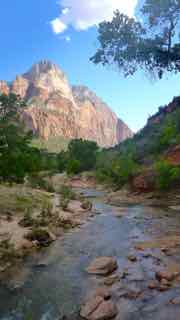
The above is a view along the bike path to the junction.
After our ride and a late lunch, we sunscreened our arms and legs and then wandered over to the Visitors Center to catch the shuttle bus into the canyon. We disembarked at the Visitors’ Museum to watch a film and to hear a ranger talk on raptors and large birds of the area – including kestrels, peregrine falcons, golden eagles, horned owls, vultures and giant condors. This presentation was first, and outside, and by the time it finished, my bare knees and I were happy to be inside for the 1/2 hour movie on the park.
Next on Sandy’s agenda were several hikes – one to the Grotto (no “velly good veal cutlets” here for those who remember Nanaimo’s restaurant version of such) and one to the “Weeping Rock” – a short, steep climb up to and under an overhang from which water drips. (Hands up anyone else who has seen water dripping from a rock wall! But…did you have to climb half a mile to see it?) Okay – the view was spectacular, and I was very grateful that I had brought along and donned my Gortex pants for the hike. Along the way, we spotted wild turkeys, and numerous mule deer. From the Weeping Rock, you could look up (“look way up…”) and see tiny hikers very high above us following another trail that, gratefully, Sandy did NOT want to climb. (Brochure warning: “Long drop-offs! Not for anyone fearful of heights!”) We finally headed down, and caught the next shuttle bus back to the campground, where we spent most of the evening tucked into Truck House with the furnace on. (This morning, the temperature is only slightly above freezing, but the sun has finally reached into our campsite!)
The Activity Planner’s schedule for the day is to do a short hike and then bike into Deep Creek Coffee for wifi access. We’ll see. Tomorrow we will head a bit south into Page, Arizona for another scenic tour. Then, the plan is to take an “S-shaped” route back into Utah through Monument Valley and up through Bryce National Park before heading east and southeast through Moab – perhaps with travelling companions – from Whitefish, Montana.
Much love and best wishes to you all!
Tony (Quill and Route-Planner) and Sandy (Quilter, and Activity-Planner)
April 15, 2015 – Sailing weather!
Yesterday, we rode our bikes – slowly into Springdale, for this was our first time on bikes in some months, and bottoms needed breaking in! Also, Sandy’s brake cable wouldn’t completely release meaning that she was riding with her brake partially on. (N.B. Both “in” and “on” are adverbs, not prepositions, so don’t my case get on! Okay, now you can!) Back to the tale before I so rudely and inconsequentially interrupted myself…
…I could have offered to ride her bike and given her my more free-wheeling one, however, she has been whinging about lack of exercise, so… The Zion Bike Shop in Springdale quickly replaced her brake cable, and pointed to a small coffee shop down the road called “Desert Pete’s” where we could get free wifi. That place will be our “go to” spot for delivering blog notes as they develop. (N.B. See next blog…this is NOT the name of the coffee shop!)\
After a lengthy wifi encounter, we saddled up and headed on downhill against an increasingly strong wind trying to push us back to Desert Pete’s. (The bike guy told us that these winds could become quite strong, as evidenced by the name of a town to the south – “Hurricane”!) Downhill (and upwind) held no bank nor liquor store. (In Utah, wine can only be purchased in liquor stores, and NEVER on a Sunday!) So, we turned around and rode back uphill (and downwind, of course) to Desert Pete’s where, just across the street, we found the bank. We got our money, asked for directions, and were directed back downhill (and upwind) to a hotel complex that housed the liquor store. And so, with much dust in our eyes, we turned and headed toward “home” uphill (and downwind) arriving back at our site in the early afternoon.
We rested our sore buttocks for a while, and then walked to the Tourist Info Center to catch a shuttle bus into the park canyons in order to do some hiking and exploring on the trails. We (Sandy’s call, if I recall correctly – not always a safe assumption any more) elected to hike UP to the third Emerald Pool above Zion Lodge. This is a 1.3 km round trip mostly involving a stair-climbing-type of bodily exertion. It turned out that the very strong winds that we experienced in Springdale had found their way into the canyons, and provided some impressively strong swirling gusts that swept water “falls” into sideways “sprays”! The 3 pools were “nice” but the third (and highest) was the prettiest. The view returning from the third pool was ahh-inspiring (as in “Ahh…so glad we could stop for a moment”) and also awe-inspiring! The value in the hike was certainly the exercise. However, as awe-inspiring can be had anywhere you look in Zion, and an escalator to the pools would have suited me just fine, we could have continued the process of resting our buttocks back at the campsite in our anti-gravity chairs! (I joke, of course!)
Winds continued to hit at or near the forecast strengths of 60 mph for the rest of the afternoon and evening, and we spent the time gratefully tucked away in Truck House, in reading positions with the heater going, as the temperatures dropped. We loaned one of our chairs to the campers next door who seemed to be struggling to find a few moments to relax between moments of trying to hold their tent down, and keeping a fire going – with smoke coming our way.
Today, everyone is walking around with down-filled jackers, hoodies, toques and gloves. The sun is shining, but apparently winter is making a comeback! We will wait until it warms up a bit, and then perhaps ride our bikes in to Desert Pete’s for more caffeine and Wifi!
And meanwhile, we read – something that Sandy is very used to doing regularly, but for me is a novel experience – or non-fiction, as the case may be! We have finished several intellectually and emotionally charged books while the winds blew! I finally got around to a book recommended to me by my sister-in-law, Margie – “Tuesdays with Morrie” by Mitch Albom, which was mostly completed in one sitting. I read this right after I had completed my second reading of “Under the Banner of Heaven” by John Krakauer. The latter book is a very powerful story that relates a history of the Mormon Church while telling the story of two brutal murders in a Utah town near Provo. This book is extremely interesting (as should be apparent since it was my second reading!) and explores events in the history of Utah. The first book “Tuesdays with Morrie” was an emotionally engaging story of the last shared Tuesday meetings between a professor (Morrie Schwartz) and his student (Mitch Albom) after Morrie learns that he has ALS.
Sandy finished laughing and weeping her way through a tale by Miriam Toews – “All My Puny Sorrows”. It sounds like I might have to read it, but I need some escape lit first!
May you all continue to have love, and laugh a lot in your lives!
Tony and Sandy
